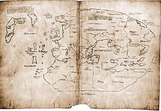
Secrets: A Viking Map?
Stars
3
Rating
PG
Author
Length
46 min
Director
Kenton Vaughan

Synopsis
"Secrets looks at the Vinland Map which was supposedly created fifty years before Columbus. The map clearly features the coast of North America. If it is real, it shows that Europeans knew about North America in the years before Columbus. Experts try to determine whether the map is real." [IMDb]
This smithsonianchannel.com production investigates the Vinland Map. Is it a fake? The Viking settlement at L'Anse aux Meadows on the northern tip of Newfoundland proves that the Vikings were in North America, at least for a decade. Butternuts found at that settlement suggests that the Vikings lived in areas of North America much farther south, and perhaps had settlements near the St. Lawrence River lasting as long as a century.
This smithsonianchannel.com production investigates the Vinland Map. Is it a fake? The Viking settlement at L'Anse aux Meadows on the northern tip of Newfoundland proves that the Vikings were in North America, at least for a decade. Butternuts found at that settlement suggests that the Vikings lived in areas of North America much farther south, and perhaps had settlements near the St. Lawrence River lasting as long as a century.
Genre
Documentary
Released
2013
Location
Europe & America
Period
Leif Erikson lived circa 970-1020 AD. "According to the Sagas of Icelanders, he established a Norse settlement at Vinland, tentatively identified with the Norse L'Anse aux Meadows on the northern tip of Newfoundland in modern-day Canada." [Wikipedia]
Netflix
No
This movie is linked to the following periods
PeriodMinor
Begin
End
Category
Other Region in 10th Century
900
999
Other Regions